by Geoffrey Goreham ( © 1972 )
Acknowledgments
Norwich Central Library, (Rye and Colman Library), Norfolk and Norwich Records Office, Norfolk County Library, Norwich Diocesan Registry, Swains (Photographers) Ltd., A.D. Griggs, Esq.
Published by the Thorpe Hamlet Association Norwich Secretary: 'Kett's Castle Villa' 113 St. Leonards Road, Thorpe Hamlet, Norwich, NOR 29S.
CONTENTS
Location 1
Population 1
Area 1
Development 1
Aspland House Estate 2
Hill House Estate 2
Grove House Estate 2
Stanley Avenue/Residential Desirability 2
Geology 2
The Rosary 2
Edwardian Development 2
Kett's Hill 2
Public Services 3
Contours and Views 3
Kett's Rebellion (1549)
3
St. Leonard's Priory 3
Mount Surrey 3
St. Michael's Chapel 3
Lollards' Pit 3
Chalk Workings 3
The 20th Century Victorian Suburb 3
Thorpe Hamlet, forming the ecclesiastical parish of St. Matthew the Apostle, lies to the south east of the City of Norwich and is included within the city boundary. Having an area of approximately 750 acres, it was formerly part of the adjacent parish of Thorpe St. Andrew or Thorpe-next-Norwich to the east both districts forming part of the Blofield Hundred of Norfolk.
The river Wensum flowing in a valley between the rising plateau of land on which the city stands, divides the Hamlet from the city. Thorpe Hamlet forms the south-east plateau and rises gently to a height of between 140-150 feet, much of the area being at one time part of the great common of Mousehold Heath.
Blofield Hundred, a division of a county with its own courts, once included the Norwich parishes of St. Helen, St. Martin-at-Palace and St. Paul together with Tombland and the meadowland by the river Wensum.
The development of the area in the early 19th century increased its importance as a growing suburb and in March, 1852, some seven months after the building of the parish church of St. Matthew, Thorpe Hamlet was constituted a separate ecclesiastical parish from the old civil-parish of Thorpe. At the time of the building of St. Matthew's church the population was 1,811, but between 1851-1901 the population increased by 5,090, most of this increase coming in the 20 years between 188I- 1901 when the population rose from 2,864 to 6,450, an increase of 4,037. In the next decade between 1901-191 1 there was a further increase of 2,126. The building of the Pilling Park Housing Estate in the early 1930s to the north- east of the parish added to the population figures and by 1951 the population had well exceeded 10,000. Today the population is estimated at nearly 12,500.
The eastern boundary of Thorpe Hamlet forms the old 1403 boundary of the city which was confirmed in 1556, and follows the line just cast of Thorpe Road including part of the grounds of Thorpe Lodge on the Yarmouth Road, turning westwards opposite the junction of Harvey Lane and Stanley Avenue and then along Harvey Lane to a point opposite Morse Avenue where the boundary curves slightly eastwards to cross St. William's Way to a point past the Heartsease roundabout in Plumstead Road East joining Heartsease Lane near the Valley Drive to the boundary of Mousehold Heath.
The southern boundary follows the line of the river to Carrow Bridge then turns north-cast along the route of the loop of Carrow Road, turning north again to the Carrow Road railway bridge. The boundary then curves south between the Gothic Works and the railway line to the river. From this point the river frontage is followed again to the cast boundary of Norwich.
To the west, the boundary follows the slightly curving line of the river Wensurn from Foundry Bridge including Riverside Road, the east side of Bishop Bridge Road, the roundabout junctionof Kett's Hill and Barrack Street and includes a part of Gurney Road as far as the south edge of St. James Hill on Mousehold Heath.
The north boundary includes the site of Spitalfields (demolished 1971) and a small area of land north of Kett's Hill to a point along Britannia Road, then north-west along Britannia Road to the south boundary of Mousehold Heath.
Within this area lies the undeveloped land of Lion Wood, a valley, thickly wooded, of about 8 acres; the open area of the Mousehold Reservoirs including the Telegraph Plantation, the eleven acres of Woodrow Pilling Park, the Rosary Cemetery and the Valley Drive woodlands.
The older residential and industrial areas of Thorpe Hamlet are located to the west and south on sloping ground above the river Wensum and Riverside Road, along the ridge north of Thorpe Road and on the high sloping land south of the Rosary Cemetery. This older area is bi-sected with main traffic roads of which Thorpe Road, Riverside Road, Quebec Road and Kett's Hill are the more important.
The more recent residential development (pre- 1939-45 War) lies to the north-east including residential building along Plumstead Road and the Pilling Park Housing Estate. The council house project was built on the former estate of Mousehold House which the Norwich Corporation purchased in 1930.
At the south end of Telegraph Lane, Cintra Road was developed as a private venture and forms a link with Wellesley Avenue (South), the two parts of Wellesley Avenue divided by the western side of Lion Wood and the existing grounds of Mousehold House, now developed as flats.
Further north in Telegraph Lane are the buildings of the former Crome and Stuart Schools, built in the 1930s and having extensive playing fields to the south-west. Other school buildings in the parish include the Wellesley Avenue Infants School and the Thorpe Hamlet Junior School in Wolfe Road, built in the 1950s.
A greater part of the rising land fronting Bishop Bridge Road, between Gas Hill and Egyptian Road contains the industrial buildings of the Eastern Gas Board where two large gasholders dominate the foreground of the tree-lined slope which rises from 20 feet to 140 feet to a plateau on which some early 19th century development between St. Leonard's Road and Quebec Road could be found (now demolished under the Camp Road redevelopment scheme).
In the area between Riverside Road and Rosary Road the sloping land was closely developed in the late 19th century pattern of parallel streets. It was here that the parish church of St. Matthew was built on land given by the Dean and Chapter.
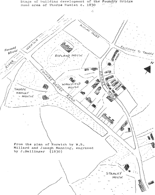
Illustration © Building development around Foundry Bridge C1830
© 1972 Geoffrey Goreham