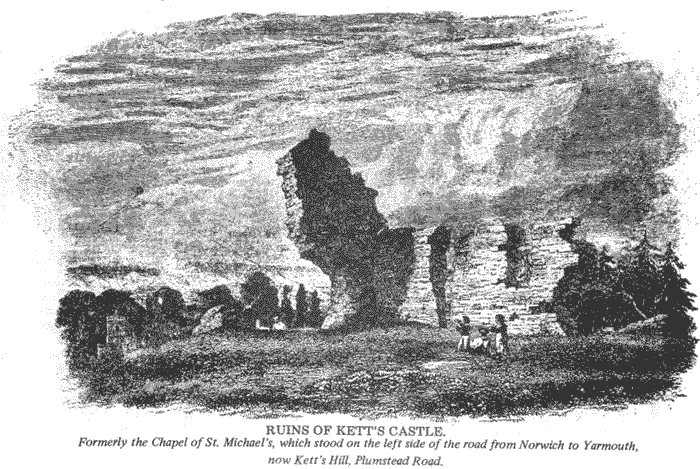
 © RUINS OF KETT'S
CASTLE. [engraving] Formerly the Chapel
of St Michael's, which stood on the left side of the road from Norwich to
Yarmouth, now Kett's Hill.
© RUINS OF KETT'S
CASTLE. [engraving] Formerly the Chapel
of St Michael's, which stood on the left side of the road from Norwich to
Yarmouth, now Kett's Hill.Home Back to the contents links Previous page
© 1972 Geoffrey Goreham
A conspicuous feature on the Thorpe Hamlet skyline seen from the west is the water tower of the Mousehold Reservoirs located in a spacious area of woodland off Quebec Road and Telegraph Lane. This tower, like a concrete gasholder, was erected in 1932-3 and forms part of the Mousehold Waterworks which were established in this part of Thorpe Hamlet in the late 19th century.
The Mousehold Reservoir site is located on the highest part of the Hamlet and it is said that the 80 foot water tower stands near the site of the famous Oak of Reformation where Robert Kett held his Courts of Justice during the Norfolk Rebellion in 1549.
In the 1920s, a large site on the river marshes within the parish was taken over by the Electricity Board and a new power station was built on the site. Thus today, all three main services, gas, water and electricity are located within the parish area.
The natural contours and levels of Thorpe Hamlet provide the artist and photographer with a remarkable opportunity to obtain some fine views of Norwich from the southeast Although later development has tended to blot out the magnificent sweeping views enjoyed by 18th century Norvicensians, some impressive landscape vistas can still be enjoyed particularly near the Gas Hill - St. Leonard's Road junction; from the steps of St. Michael's Terrace and from the site of St. Michael's Chapel. Unfortunately, the foreground is spoiled somewhat by the framework of the gasholders on the ridge below.
It was from around this area that Samuel and Nathaniel Buck drew inspiration for their "South-East Prospect of the City of Norwich" engraving published in 1741. The Georgian figures sitting or strolling on the high ground overlooking the city had a fine view of the river as it curved away between marsh and meadow to Carrow. From the position of the ridge in the engraving it would appear that the view was originally sketched from the high ground above the Chalk Hill Works on Rosary Road, possibly near the site of the large detached Edwardian house known as the "Clyffe".
© RUINS OF KETT'S
CASTLE. [engraving] Formerly the Chapel
of St Michael's, which stood on the left side of the road from Norwich to
Yarmouth, now Kett's Hill.
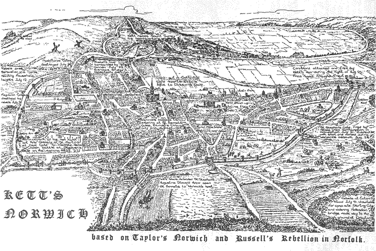
Robert Kett and his rebels found this part of Thorpe Hamlet (Mousehold as it was then) an ideal site for the so called "King's Great Camp" in 1549. Hence the name 'Kett's Hill' and 'Camp Road'. Kett used the ruins of St. Michael's Chapel on the ridge as his headquarters and also St. Leonard's Priory close by at the top of Gas Hill. The advantages gained in setting the camp in such a strategic and commanding position was ample compensation for being denied free economic access to the city. Indeed, from this prominence, Kett could dominate Norwich, sprawled open and practically defenceless below the chalk hills and it is to be remembered that it was only when Kett abandoned the camp and met the Earl of Warwick on flat open ground that he was defeated.
Illustration © Kett's Norwich an annotated sketch map
The Norman Conquest and the building of the Cathedral on the marshes to the south-cast near the river was followed by the budding of the first permanent houses on the wooded incline above the old river crossing at Bishop Bridge. It is recorded in the "Registrum Primum" of Norwich Cathedral that Bishop Herbert, the founder “…Having acquired in the year 1101 the Manor of Thorpe and Thorpe Wood, built the church of St. Leonard on a certain hill of the same wood and also the chapel of St.Michael near the church and priory to replace the chapel and land of St. Michael then and now called Tombland which he removed in order to make an entrance to the Cathedral Monastery…” St. Leonard was a French noble who died in the year 559, and in his book, "A History of Thorpe-next-Norwich", the Rev. William Supple suggests that the dedication of the priory of St. Leonard was possibly due to the fact that the saint had made himself a hut in a wood where he lived a life of devotion, assisting those who came to him for help and counsel. The establishment of St. Leonard's Priory was an historic event in the history of Thorpe Hamlet and influenced the development of the area long after the priory had disappeared. The grounds covered 24 acres, the precinct wall apparently following the line of St. Leonard's Road to its junction with Rosary Road. The Priory, being a cell to and dependant on the Cathedral Monastery, the prior of the cell and the custodians were appointed by the Prior of Norwich, the seven or eight monks performing daily service in the adjacent chapel of St. Michael. East of the Priory, a broad strip of forest land, alternating with heath and moor, extended to the north-east of Pockthorpe along the crest and southern slope of Mousehold as far as Postwick. This was Thorpe Wood, the hunting ground of the Bishops of Norwich whose county lodge or palace (site of Thorpe Old Hall) was established at the south edge of the wood near the river in Thorpe St. Andrew.
In 1538 came the Dissolution and the king granted the site of St. Leonard's Priory to Thomas, Duke of Norfolk whose son, Henry Howard, Earl of Surrey, built a fine house near the site of the desecrated priory calling it "Mount Surrey". Later the family fell from favour and in 1547 the Earl was beheaded, his house and land reverting to the Crown. Although at a later date the Howard family were restored to royal favour and Queen Elizabeth granted the property to Thomas, Duke of Norfolk, the son of Henry Howard, Earl of Surrey, the Howard family abandoned the site of Mount Surrey. The house again declined and became derelict and by the early 18th century there was a farmhouse on the site. The present house was built in the 19th century but it is possible that parts of the old house were incorporated in the building. Apart from a few fragments of the wall, little remain of the old priory buildings although the site is still of interest to historians and archaeologists.
This chapel, founded outside the precinct wall of St. Leonard's Priory, was built to replace the church of St. Michael in Tombland which was demolished to extend the Cathedral Monastery. The chapel was built on a jutting prominence some 200 yards from the church. It was a small oblong shaped building about 42 feet in length and about 18 feet in width.
At the time of the Dissolution it was abandoned and later occupied by the Norfolk rebels under Kett. Much of the old flint walling was destroyed at this time but for over three centuries substantial remains of the chapel could be seen from the city. In the 19th century the ruined chapel was known as "Kett's Castle" or "Old Father Tyme" because the ruins of the north and west walls resembled the face of an old man when seen at a distance. Moreover, in the 19th century the foundations could be traced as well as the remains of four small circular towers or turrets. The ruins, standing stark against the skyline, can be seen on many old prints, and in the early 19th century the chapel was the subject of a painting by John Sell Cotman in which he depicts the ruins against a darkening sky with a windmill and a donkey to emphasise the loneliness of the scene. This painting, called 'Ketts Hill' can be seen in the Cotman gallery at the Norwich Castle Museum.
Very little of the old ruins remain, only a small portion of a flint wall forming part of a brick garden wall and the ruins of a greenhouse. The site of the chapel now stands on a piece of land owned by the Eastern Gas Board off St. Leonard's Road and the area immediately below the ridge is occupied by the buildings of the Gas Works.
In the mid-16th century religious intolerance and persecution had reached frenzied proportions and under Mary Tudor, Protestants and Lollards were dying in the fires kindled all over the country. In Norwich the site chosen for the execution of heretics was a large chalk pit dug into the hills nearly opposite Bishop Bridge. This pit, part of the Thorpe Woods and held by the Bishops of Norwich was probably the site of the chalk workings and limekiln which had been leased to John Goldyng in 1544.
Old prints of Norwich show Lollards'Pit as “…the place where men are customably burnt…” and George Borrow writing of this tragic spot said “… many a saint of God has breathed his last beneath that white precipice, midst flame and pitch; many a grisly procession has advanced… …across the old bridge towards the Lollards hole…”
Long after the pit had ceased to be used for executions it was considered an evil place and was avoided if possible by travellers. However by the 19th century the site had become a camping ground for gipsies Today the site of the pit has largely been built over and a large gasholder dominates the area on the hill. The open space left on the site is now (1972) used by the E.G.B. as a dump for various materials.
The chalk workings around the site -from which Lollards' Pit was formed led to the chalk tunnels, it is said, have been worked since the 11th century. About a hundred years ago extensive tunnels of chalk were discovered under the hill by the Rev. J.W. Hayes, from which about 25,000 yards of material had been taken for lime burning. Rosary Road in this area was once known as Chalk Hill and near the Chalk Hill works on the rise of the hill some older excavations were found. Here two main tunnels had been driven into the side of the hill to a distance of about 133 feet. The tunnels were 10 feet high and 8-10 feet wide. Some 20-30 feet from the entrance of one of these tunnels, other small tunnels (about eleven in. all) branched off at right angles, each 50-60 feet long, one being 20 feet in length and about 10 feet wide. From these earlier tunnels some 20,000 yards of chalk had been taken, probably to be used as lime in the building of the cathedral. In the early 19th century the lime-kilns and chalk workings around this area were fully exploited but by the end of the century housing and industrial development had made access to the pits and tunnels difficult and they eventually were abandoned. However, they continued to be used as places for storage. Thompson & Sons, for instance, used the caves and tunnels when they occupied the Chalk Hill Works site as a natural storehouse for iron, zinc and tin, erecting two stout doors at the entrances to the main tunnels. In the 19th century Coleman's Brewery Company occupied the site and used the tunnels for extensive storage. The disused pit further along Rosary Road on the higher level was to be excavated and laid out as a football ground in 1908 (The Nest - Norwich City F.C.). The chalk excavated from these workings was transported away by water and another tunnel existed under Rosary Road to a tip by the side of the river. This old tunnel entrance with its level at Riverside Road leading up the slope to the site of the Chalk Hill Works depicted on a map of the city of Norwich prepared by Mr. A.W. Morant, the City Surveyor in 1873. This map also indicated another tunnel leading from the old football ground chalk pit to a second landing stage along the river.
THE 20TH CENTURY VICTORIAN SUBURB
The residential and industrial development of Thorpe Hamlet was influenced by a number of events which, although unrelated as a whole, acted as a stimulus to builders. A comparison of district development in Norwich in 1870 gives a clear indication that the natural barriers of land contours restricted the early expansion in Thorpe Hamlet. Whole districts like the 'New City' and the 'Peafields' to the west of the old city wall line were created on land which presented little or no difficulty to the builders and in 1870 this expansion was flowing evenly. In Thorpe Hamlet however development was slow and disjointed, much of the residential development following the line of the main Yarmouth Turnpike and on the low ground around the foot of the hills. Spitalfields and Weeds Square, built in the 1820s were examples of this early development to be repeated later on the higher slopes along Chalk Hill (Rosary Road).
The establishment of the Gas Works opposite Bishop Bridge in 1830 was a significant industrial event because it created for the first time a need for small cottage building in direct contrast to the more leisurely selective house and terrace development that had begun to spread on the wooded slopes of the Hamlet. Within 20 years following the establishment of the Gas Works, a closely built-up area of small cottages and houses had been created on the plateau around St. Leonard's Road between Gas Hill and Kett's Hill. During the latter half of 1969 and throughout 1970 almost all of this cottage development was demolished under the Camp Road Re-development Scheme and plans were prepared and-approved for the new housing for the site.
The coming of the railway in 1844 south of Foundry Bridge Road further encouraged residential development and this was re-emphasised by the construction of Prince of Wales Road in 1862 which opened up a new approach to the south-east side of the city. The erection of houses along the Thorpe Road and also along the ridge around Rosary Road was now accelerated.
Thorpe Hamlet, however, even at this date was predominately rural and it was not until the speculative exploitation of the large private estates, the budding of a Board school and the construction of Riverside Road in the late 19th century, that terrace house building spilled over the west side of the parish. This rapid, almost frenzied development which also included the establishment of Britannia Barracks (1886) and a new prison (1885) in the parish, slowed and lost impetus during the first two decades of the 20th century. Further residential expansion along Plumstead Road at the junction with Kett's Hill, another church (St. Leonard's - 1907), terrace house building at the north end of St. Leonard's Road, the construction of Britannia Road, the widening of Telegraph Lane and the sale and development of the Grove House estate (1 903-1912) were also part of this continuing process. Industry too was seeking new sites and established works and factories were expanding.
In this period Thompson and Sons, were established at the Chalk Hill Works on Rosary Road and in Thorpe Road a large house with extensive grounds was purchased by Laurence, Scott & Electromotors for industrial expansion. In the years between the wars the momentum of development was speeded up, new residential areas being created on land to the north-east. To the south the Norfolk County Council, by gradual acquisition, purchased old property along Thorpe Road and established their offices in the area. Here they were to stay until the late 1960s when the new County Hall in Martineau Lane was built. The pattern of ribbon development characteristic of the 1930s saw the building of semi-detached houses along Plumstead Road to the Heartsease and the building of new schools under the Hadow Report. It was during this period that Montcalm Road was constructed as a private building scheme south of Wolfe Road.
The 1939-45 war brought a halt to the expansion and the post-war period has seen the filling of the gaps left during the two rapid stages of development. Residential building in the Hamlet has become more selective and certain redevelopment has replaced some of the older property, as in Rosary Road where a number of small cottages and terraces were demolished and tall municipal flats built on the site. Also in Rosary Road old property known as 'The Mount' has been replaced by more flats and is now known as 'Thorpe Heights'. With much of the remaining building land now taken for residential building; (even the grounds of Mousehold House have disappeared for flats known as 'Woodrow Place', the emphasis will shift to redevelopment, road-widening and reconstruction. It seems clear that old property to the west of the parish will be cleared for modern housing (i.e. Camp Road Scheme) and future residential growth will continue to shift to the east.
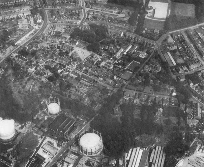
Illustration © Aerial view of Camp Rd and Gas Hill area C1962
© 1972 Geoffrey Goreham